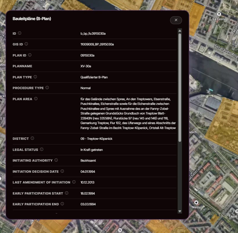
What is a Bebauungsplan (B-Plan)?
A Bebauungsplan is the legally binding tier of German planning: it defines what may be built on a specific area, at what density, and for which use. Plans are published municipality by municipality, often as scanned PDFs behind a portal. We extract the plan geometry and the key attributes, and keep the source document one click away, so your team can verify any finding before acting on it.
Is a Bebauungsplan legally binding?
Legal status
Legally binding
This designation has direct legal effect. It can permit or prevent what you build on a site.
A Bebauungsplan is adopted as a municipal statute (Satzung) under §10 BauGB and is legally binding. Where a qualifizierter B-Plan exists, one carrying the four determinations of §30 (1) BauGB, a project is admissible if it complies with them. An einfacher B-Plan settles less. The remaining questions are judged under §34 BauGB inside built-up areas or §35 BauGB outside them.
What this means for you
This is the layer that answers whether you may build what you intend. Its worth is decisiveness: a designation of Industriegebiet or Gewerbegebiet either matches your plan or rules the site out. And because every polygon links to the authority's own source document, the answer holds up in front of a committee or a lender.
What information does Bebauungsplan data contain?
Plan type
Whether a plan is a qualifizierter B-Plan (§30 BauGB, full building rights) or a simpler variant, so you know how much the plan actually settles.
Permitted use (Nutzungsart)
The designated uses carried through as text: Gewerbegebiet, Industriegebiet, Allgemeines Wohngebiet, Sondergebiet and combinations of them.
Source document
A direct link to the publishing authority's plan document, so every finding stays auditable.
Object ID and geometry
A stable identifier plus polygon geometry for joins against parcels, portfolios or catchments.
The four attributes above are the harmonised core we make comparable across states. Beyond that, depth follows the source: some municipalities publish detailed textual determinations, others little more than geometry and a link to a scanned plan. We preserve what exists rather than flattening every plan to a lowest common denominator.
What is Bebauungsplan data used for?
- Confirming whether a specific site permits Gewerbe or Industrie use before an offer is made. The designation either matches your plan or rules the site out early.
- Building a pipeline of development-ready areas across several federal states from one query, instead of reading each municipality's plan portal separately.
- Due diligence before an acquisition: which plan applies, what it permits, and the authority's original document one click away for your legal advisor.
- Feeding permitted-use constraints into a site-selection or scoring model, so binding zoning acts as a filter in the analysis rather than a manual check afterwards.
Where does Bebauungsplan data come from?
Official state geoportals and municipal planning services. Every polygon keeps a reference to the publishing authority, so any record can be verified at origin.
Which federal states publish Bebauungsplan data?
Bebauungsplan data is published in 12 of 16 federal states. Where the state publishes it, we carry it. It is not published at source in Bavaria, Hesse, Lower Saxony and Saxony-Anhalt: Bavaria offers only raster viewing services, and Hesse and Lower Saxony scatter plans across municipal portals.
Coverage by federal state
- BBBrandenburgAvailable
- BEBerlinAvailable
- BWBaden-WürttembergAvailable
- BYBavariaNot published by the state
- HBBremenAvailable
- HEHesseNot published by the state
- HHHamburgAvailable
- MVMecklenburg-Western PomeraniaAvailable
- NILower SaxonyNot published by the state
- NWNorth Rhine-WestphaliaAvailable
- RPRhineland-PalatinateAvailable
- SHSchleswig-HolsteinAvailable
- SLSaarlandAvailable
- SNSaxonyAvailable
- STSaxony-AnhaltNot published by the state
- THThuringiaAvailable
Where the federal state publishes this layer, we carry it: 12 of 16 federal states today. Where it doesn't, we say so.
Coverage gap
Your region of interest isn't covered?
Coverage follows what each state and municipality has actually digitised, so there are real gaps, and they are not always where you would expect. Tell us the region and the layer you need and we will look into what can be sourced for it, including data we do not list today.
Tell us what you needHow do you get Bebauungsplan data?
One unified dataset: Ready for direct integration into your GIS, CAD, or BI tools. Standard formats, documented schema.
Mapular Explorer: Instant planning interface, no GIS setup required. Filter, analyse, and export from your browser.
Frequently asked questions about Bebauungsplan data
What is a qualifizierter Bebauungsplan?
A B-Plan containing at least the four determinations listed in §30 (1) BauGB: type and degree of building use, buildable areas, and local traffic areas. Where one exists, a building application is judged against the plan itself. Simpler plans leave more to be assessed under §34 BauGB inside built-up areas or §35 BauGB outside them.
Why is there no Bebauungsplan data for Bavaria, Hesse, Lower Saxony or Saxony-Anhalt?
These four states do not publish Bebauungsplan data at source in a form we can carry. Bavaria offers plan geometries only as WMS raster viewing services rather than vector data. In Hesse and Lower Saxony, plans sit scattered across per-municipality portals, often as PDFs. Where the state publishes it, we carry it; for these states we source plans individually on request.
Can I get Bebauungsplan data for one region only?
Yes. Define your area of interest with a custom polygon, postal codes or administrative boundaries, and the layer is delivered clipped to that geography. Pricing follows the area and the layers you select, so a single-region extract is a normal order for us, not a special case.
Can we rely on Bebauungsplan data for a permit decision?
Use it to shortlist sites and to know which plan applies, not as the permit itself. Every polygon links to the publishing authority's own document, which is what you or your legal advisor should read before committing. We make the plan findable and comparable, we do not replace it.
What if a plan is newer than your data?
Possibly not yet in the layer. We carry what authorities have published, and publication itself lags behind adoption in some states, so a very recent plan or amendment may not have appeared at source. Every polygon keeps a link to the publishing authority's document, so you can always confirm the current plan status at origin.
How does the Bebauungsplan layer combine with other layers?
Directly. It shares the geometry model and identifiers of the rest of the Mapular catalog, so one query can combine binding B-Plan designations with preparatory Flächennutzungsplan intent or other layers. You could require a Gewerbegebiet designation within a defined catchment, for instance, instead of running separate analyses and reconciling them by hand.