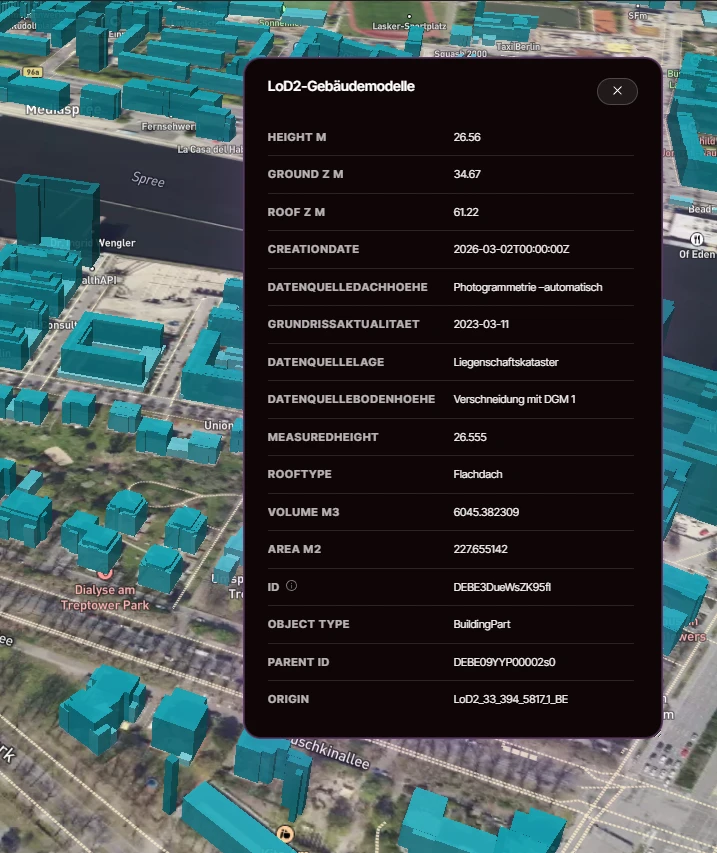
Was sind LOD2-Gebäudemodelle?
LOD2-Gebäudemodelle sind 3D-Gebäudemodelle im CityGML Level of Detail 2: jedes Gebäude als Körper mit Grundfläche, gemessener Höhe und standardisierter Dachform, also Satteldach, Walmdach, Flachdach und die weiteren gängigen Formen. Sie werden von den Landesvermessungen aus amtlichen Geodaten abgeleitet und bilden damit den 3D-Referenzbestand der Gebäude in Deutschland. Wo eine Frage davon abhängt, wie hoch ein Gebäude ist und wohin sein Dach zeigt, beantwortet LOD2 sie im nationalen Maßstab.
Wie amtlich sind LOD2-Gebäudemodelle?
Rechtliche Wirkung
Referenzdaten
Belastbare Grundlage für Analyse und Screening. Eine eigene rechtliche Wirkung hat sie nicht.
LOD2-Modelle werden von den Landesvermessungen aus amtlichen Daten wie Kataster und Höhenmessungen abgeleitet. Sie sind Referenzdaten für Analyse und Visualisierung: amtlich in der Herkunft, standardisiert in der Form, aber keine beglaubigte Vermessung eines einzelnen Gebäudes.
Was das für Sie bedeutet
Für Arbeit im Portfoliomaßstab ist das genau das richtige Niveau: Dachformen und Höhen, die über eine ganze Stadt oder ein ganzes Land vergleichbar sind, mit einer Herkunft, die Sie belegen können.
Welche Attribute führen LOD2-Gebäudemodelle?
Dachform
Standardisierte CityGML-Dachformen (Flachdach, Satteldach, Walmdach und mehr), das Attribut, mit dem Solar- und Verschattungsstudien beginnen.
Gebäudehöhe
Gemessene Gebäudehöhen, die aus einem 2D-Grundriss ein Modell machen, gegen das sich Sicht und Verschattung rechnen lassen.
Grundfläche
Die Grundflächengeometrie des Gebäudes, konsistent mit dem amtlichen Gebäudebestand, aus dem sie abgeleitet ist.
Funktionsklasse
Die Funktionsklassifikation des Gebäudes, die Wohn-, Gewerbe- und öffentlichen Bestand mit einem Filter trennt.
Alle 16 Länder veröffentlichen LOD2, aber jede Landesvermessung erzeugt ihre eigenen Modelle, weshalb Erfassungsstand und Modellierungsdetail je Bundesland variieren. Die CityGML-Struktur ist überall gleich. Wir harmonisieren die Länderauszüge in ein Schema und benennen die Unterschiede, statt sie zu glätten.
Wofür werden LOD2-Gebäudemodelle genutzt?
- Solar- und PV-Potenzialanalysen aus Dachform, Ausrichtung und Fläche
- Verschattungs- und Sichtbarkeitsstudien für Planung und Projektentwicklung
- 3D-Visualisierung städtebaulicher Szenarien und Wettbewerbe
- Kontextmodelle für BIM- und Digital-Twin-Projekte
Woher stammen LOD2-Gebäudemodelle?
Erzeugt von den Landesvermessungen und über deren amtliche Geoportale veröffentlicht; wir harmonisieren die Länderauszüge zu einem bundesweiten Datensatz.
Für welche Bundesländer gibt es LOD2-Gebäudemodelle?
Alle 16 Bundesländer. LOD2 gehört zu den wenigen amtlichen 3D-Datensätzen mit bundesweiter Veröffentlichung, und diese Ebene führt ihn als ein harmonisiertes Modell von Flensburg bis Garmisch.
Abdeckung nach Bundesland
- BBBrandenburgVerfügbar
- BEBerlinVerfügbar
- BWBaden-WürttembergVerfügbar
- BYBayernVerfügbar
- HBBremenVerfügbar
- HEHessenVerfügbar
- HHHamburgVerfügbar
- MVMecklenburg-VorpommernVerfügbar
- NINiedersachsenVerfügbar
- NWNordrhein-WestfalenVerfügbar
- RPRheinland-PfalzVerfügbar
- SHSchleswig-HolsteinVerfügbar
- SLSaarlandVerfügbar
- SNSachsenVerfügbar
- STSachsen-AnhaltVerfügbar
- THThüringenVerfügbar
Wo das Bundesland diese Ebene veröffentlicht, führen wir sie: heute 16 von 16 Bundesländern. Wo nicht, sagen wir das.
Abdeckungslücke
Ihre Zielregion ist nicht abgedeckt?
Die Abdeckung folgt dem, was jedes Bundesland und jede Gemeinde tatsächlich digitalisiert hat. Es gibt also echte Lücken, und sie liegen nicht immer dort, wo man sie erwartet. Nennen Sie uns Region und Ebene, und wir prüfen, was sich dafür beschaffen lässt, auch Daten, die wir heute nicht aufführen.
Sagen Sie uns, was Sie brauchenWie können Sie LOD2-Gebäudemodelle kaufen?
Ein einheitlicher Datensatz: Bereit für die direkte Integration in Ihre GIS-, CAD- oder BI-Tools. Standardformate, dokumentiertes Schema.
Mapular Explorer: Sofortige Planungsoberfläche, kein GIS-Setup erforderlich. Filtern, analysieren und exportieren Sie direkt aus Ihrem Browser.
Häufige Fragen zu LOD2-Gebäudemodellen
Was bedeutet LOD2?
LOD2 ist Level of Detail 2 im CityGML-Standard: 3D-Gebäudemodelle mit standardisierten Dachformen und gemessenen Höhen, aber ohne Fassadendetails wie Fenster oder Türen. Es ist das Detailniveau, das die deutschen Landesvermessungen bundesweit veröffentlichen.
Was unterscheidet LOD1 von LOD2?
LOD1-Modelle sind Klötze mit Flachdach, auf eine Höhe extrudierte Grundrisse. LOD2 ergänzt standardisierte Dachformen, und genau das macht Solar-, Verschattungs- und Sichtbarkeitsanalysen aussagekräftig.
Eignen sich LOD2-Modelle für Solarpotenzialanalysen?
Ja. LOD2-Modelle führen standardisierte Dachformen und gemessene Höhen aus amtlichen Vermessungsdaten, die etablierte Grundlage für Solarpotenzial-Screenings im Portfoliomaßstab. Für die ausführungsreife Planung eines einzelnen Dachs bleibt die Aufnahme vor Ort.
Enthalten LOD2-Modelle Texturen oder Fassadendetails?
Nein. LOD2-Modelle haben geometrische Dachformen, aber keine Fassaden, Fenster oder Texturen. Das wäre LOD3. Für die meisten Analyse- und Visualisierungsaufgaben ist LOD2 der praktische Standard.
In welchen Formaten kommen die LOD2-Modelle?
CityGML ist das native Format; wir liefern auf Wunsch auch in anderen gängigen 3D- und GIS-Formaten mit dokumentiertem Schema. Wenn Ihre Pipeline etwas Bestimmtes erwartet, sagen Sie es uns.
Können wir LOD2-Modelle für eine einzelne Stadt oder Region kaufen?
Ja. Die Ebene deckt alle 16 Bundesländer ab und ist deutschlandweit, je Bundesland oder zugeschnitten auf eine von Ihnen definierte Region lieferbar. Das Schema bleibt auf jeder Ebene identisch.