Cesium Certified Developer
Custom CesiumJS
Web Applications.
We design and build interactive 3D web applications powered by CesiumJS. Digital twins, terrain-aware visualisations, and physically accurate spatial simulations that run in any modern browser.
Cesium Certified Developer

Recognised by Cesium
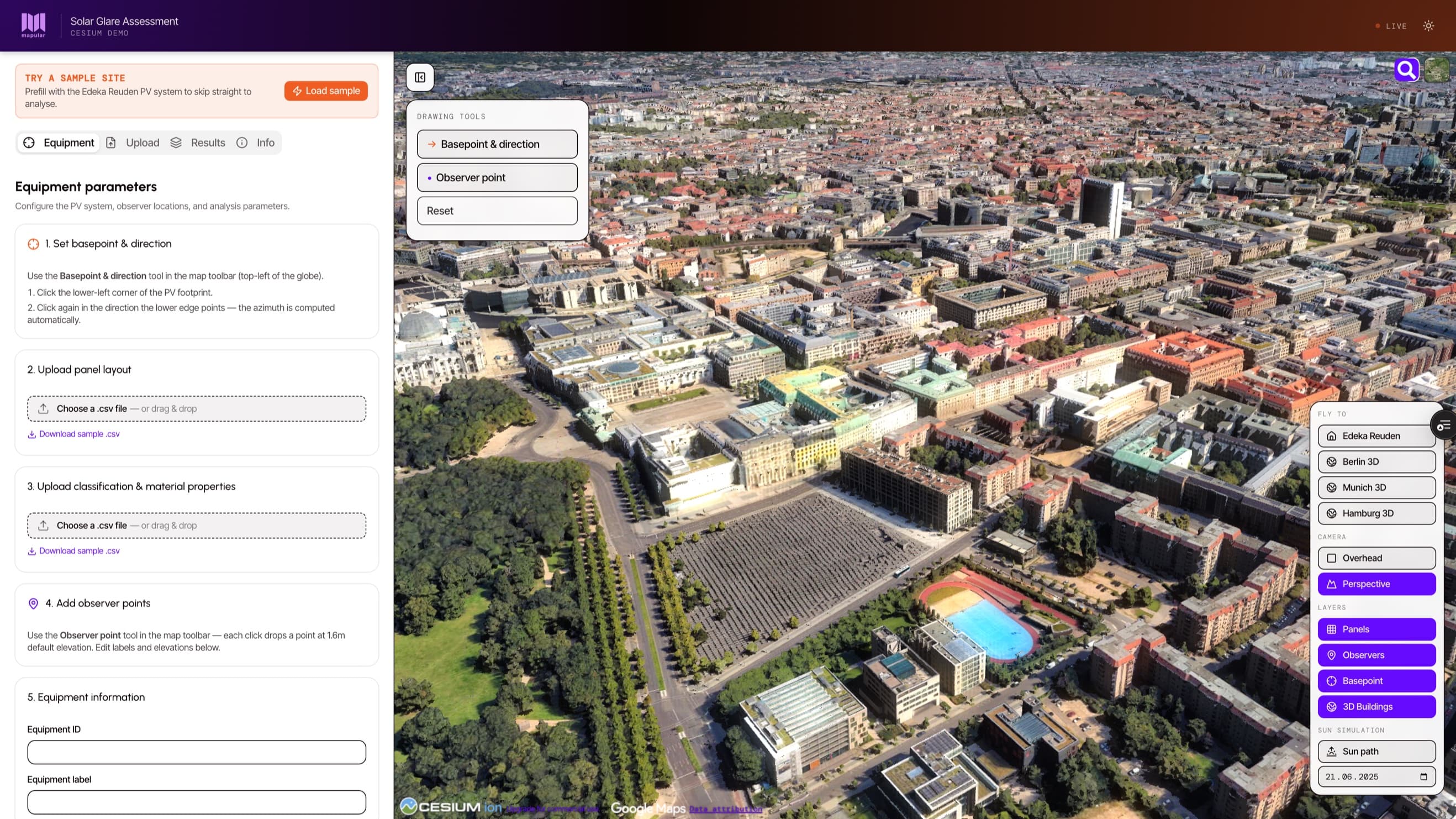
Solar Glare Assessment App
Our flagship CesiumJS project: an interactive 3D tool for assessing glint and glare from solar installations under Germany's BImSchG. Real terrain, sun-position simulation, and a regulator-ready PDF in one click.
CesiumJS · Cesium ion · React · TypeScript
What We Build
Four Core Capabilities
Interactive 3D Visualisations
Digital twins, urban planning tools, infrastructure dashboards, and environmental models. Real terrain, building footprints, and time-of-day lighting that match the physical world.
Physical Simulation in the Browser
Sun position, shadow casting, ray-tracing, and atmospheric effects. Used for solar glare assessment, line-of-sight analysis, viewshed planning, and visibility studies.
Cesium ion Asset Pipelines
Terrain ingestion, photogrammetry workflows, 3D Tiles publishing, and custom imagery layers. Whether your source is LiDAR, drone capture, BIM, or GIS exports, we get it into Cesium and serve it at scale.
Migration to 3D
We move live applications from Mapbox, Leaflet, or ArcGIS to CesiumJS without breaking user workflows or losing data integrity. The flagship example: a complete glare-assessment platform migrated end to end.
Our Approach
Real Software, Not Just 3D Demos.
CesiumJS is powerful but unforgiving. The difference between a 3D demo that wows once and a production tool that works every day is in the details — performance, data handling, terrain accuracy, and user workflows. We've shipped those details before.
We treat 3D mapping as software engineering first. Modern frontend stack, proper state management, end-to-end tested. The 3D layer is the visualisation, not the architecture.
If your challenge is a real 3D web application — one that handles real data, real users, and real performance constraints — we're the right partner.
Typical Use Cases
- Digital twins of cities, sites, or industrial assets
- Solar glare and shadow assessments for renewable energy
- Drone and photogrammetry data delivery in the browser
- Infrastructure inspection and 3D asset visualisation
- Migration from 2D mapping stacks to CesiumJS
FAQ
Common Questions
What Cesium services does Mapular offer?
We design and build custom CesiumJS web applications, set up Cesium ion for terrain and 3D Tiles, develop physical simulation features (sun, shadows, ray-tracing), and migrate existing 2D mapping applications to Cesium.
When should we use CesiumJS instead of Mapbox or Leaflet?
When the third dimension or physical accuracy matters. Digital twins, solar assessments, line-of-sight analysis, anything where elevation or time-of-day affect the result. For purely 2D use cases like store locators or route maps, Mapbox is usually a better fit.
Do you work with Cesium ion or self-hosted Cesium?
Both. Cesium ion is our default because it removes operational overhead for terrain, satellite imagery, and 3D Tiles hosting. For projects with strict data residency or air-gapped requirements, we set up self-hosted alternatives.
Can you integrate Cesium with our existing data?
Yes. We've worked with LiDAR, drone photogrammetry, GIS exports, CAD and BIM models, and live sensor streams. Whatever format your data is in, we get it into Cesium tiled, styled, and performant.
Are you Cesium Certified?
Yes. Mapular is listed in the official Cesium Certified Developer Directory. The certification was awarded for our Solar Glare Assessment App, our flagship CesiumJS project.
Your Project
Let's Build
It Together.
Tell us about your project requirements. We'll match you with the right specialists and outline a tailored approach, no commitment required.